Purpose
To find and zoom into drawing entities representing KTF levels, linear survey features and horizontal alignments.
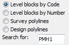
Operation
Choose what you are searching on – Codes, survey point Numbers, Codes or Road name as Xdata on Polylines. Select viewing options.