|
<< Click to Display Table of Contents >> Export to Co-ordinate file |
  
|
|
<< Click to Display Table of Contents >> Export to Co-ordinate file |
|
Purpose
To write a "matrix" grid file or a .xyz co-ordinate file from a KTF ground model.
Operation
Select the ground model.
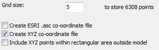
Specify the size of the grid.
Choose the output format.
The .asc file looks like this :-
ncols 83
nrows 76
xllcorner 1870.000
yllcorner 1970.000
cellsize 5.000
nodata_value -9999.000
78.670 78.509 78.989 79.290 79.152 78.939 78.616 78.357 78.327
76.012 76.094 76.158 76.222 76.285 76.373 76.544 76.591 76.605
83.846 85.341 86.831 87.080 87.235 87.391 87.546 87.664 87.767
88.075 88.119 86.877 86.350 86.534 86.707 86.879 87.050 87.203
87.728 87.850 89.799 91.876 92.009 92.142 92.314 92.499 92.660
92.779 92.897 93.032 93.216 93.400 93.583 93.767 93.997 94.374
92.353 92.494 92.635 92.776 92.917 93.130 93.394 93.658 93.902
The .xyz file looks like this :-
1880.000,2185.000,83.760
1885.000,2185.000,83.742
1890.000,2185.000,83.028
1895.000,2185.000,81.974
1900.000,2185.000,80.664
1905.000,2185.000,79.163
1910.000,2185.000,78.359
Click Start
Specify the output file name.