|
<< Click to Display Table of Contents >> Ground model intersections |
  
|
|
<< Click to Display Table of Contents >> Ground model intersections |
|
Purpose
To mark where 3D Polylines intersect a ground model.
Operation
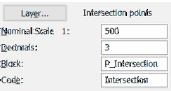
Select one or more 3D Polylines. Use the dialogue to set layer, nominal scale, number of decimal places and annotation block name (default is "P_Intersection").

Some 3D polylines going in and out of the ground model

Polylines' and ground model intersection points are marked with intersection annotation blocks

List of intersection co-ordinates