|
<< Click to Display Table of Contents >> Read GPS locations from photos |
  
|
|
<< Click to Display Table of Contents >> Read GPS locations from photos |
|
Purpose
To select a number of .jpg files that originate from a camera that also writes longitude and latitude to the file to enable the subsequent marking of locations in the drawing. Some cameras will also record the direction that the camera is pointing to and this will also be available to annotate in the drawing. Note that the main result of running this is a KTF .txt co-ordinate file that needs to be read using menu item File utilities, .txt Co-ordinate files, Input to add the locations to the drawing.
Longitude and latitude are converted to UK Easting and Northing.
Operation
Write KTF Co-ordinate file (.txt) should be "on" for typical use.
The resource file provides useful notes and a list of co-ordinates etc.
Select a number of suitable .jpg files.
Enter file name(s)
To draw the camera locations and view a photo
File utilities, .txt Co-ordinate files, Input
Select the .txt file.
Click Code assignment Special...
Browse... to highlight TAGGED INFORMATION BLOCKS
![]()
Click OK to confirm the dialogue looks like this :-
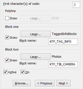
If OK click Start on the main dialogue to draw but if not
Click Set Defaults
and then Start on the main dialogue to draw.

Arrows indicate the direction that the camera is facing.
To view a photo use menu item Annotate and Enhance, Hyperlink, Go and click on a block as shown above.
Levels will not be accurate or reliable.