|
<< Click to Display Table of Contents >> Annotate levels on elevation |
  
|
|
<< Click to Display Table of Contents >> Annotate levels on elevation |
|
Purpose
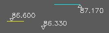
To mark levels on an elevation after drawing by the previous menu item.
Operation
Return to accept default nominal scale or enter alternative.
Return to accept default number of decimal places or enter alternative.
Return for triangle pointing down or enter "U" for upward pointing triangle.
If the elevation entities have been moved from their 0.000, 0.000 base enter "Y" to pick a location on the elevation with known Level/Y value to calibrate.
Pick a location on the elevation.