|
<< Click to Display Table of Contents >> Draw building elevation from .txt file |
  
|
|
<< Click to Display Table of Contents >> Draw building elevation from .txt file |
  
|
Purpose
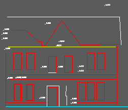
To draw the building/structure face/elevation from the file created by the previous menu item.
The 2D Polyline used to define the vertical plane sets the X co-ordinate of 0.000 and the Y co-ordinates relate to the Z values in the original data.
Do a Zoom Extents to see the elevation.
Operation
Same as menu item File utilities, .txt Co-ordinate files, Input but reading from the transformed file.
Ensure that the 2D option is clicked.
![]()

Entities drawn in "flipped vertical plane"