|
<< Click to Display Table of Contents >> Project building face observations |
  
|
|
<< Click to Display Table of Contents >> Project building face observations |
|
Purpose
To project KTF level blocks and 3D Polylines (e.g. input by menu item Land Survey, User specific Observation file Inputs) onto a vertical plane representing the face or elevation of a building, bridge or other structure. The 3D Polylines representing walls, roof, windows, doors or bridges etc. should have Xdata from the feature codes in the input file or these can be added on an individual basis by menu item Polyline utilities, Xdata Editor. This program can draw Points in elevation or can write the selected features to a .txt file after transforming the chainages of points as projected onto the 2D Polyline to X values and Levels to Y values. This “flattened out” elevation is then drawn by the next menu item. The start of the 2D Polyline has a chainage value of 0.000.

Observations to a building face - this can look very congested when viewed in plan. The 2D Polyline representing the vertical plane is shown in red.
Operation
Pick the 2D Polyline representing the vertical plane or "building projection face”.
Return to accept the default maximum distance – points beyond this distance will be ignored.
Select the level blocks and/or 3D Polylines or 3D Points.
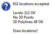
Click Yes to draw Points in elevation - this is suitable if all the data is 3D Points from a scanner for example.
Set nominal scale, pick a location to draw as Points in elevation and click No to not also write to file.

Points in elevation - these will be from 3D Point entities from a scanner in typical use.
or
Click No to Draw location?
Yes to write a .txt co-ordinate file
Enter the output .txt file name and use the following menu item to draw the elevation with the same code recognition and "joining" as in the survey input.