|
<< Click to Display Table of Contents >> from .xyz file Triangulating |
  
|
|
<< Click to Display Table of Contents >> from .xyz file Triangulating |
|
Purpose
To create a model from co-ordinate files containing random data.
2103.079,2264.680,93.777
2044.022,2246.249,89.397
2121.200,2312.103,90.164
2113.666,2319.909,89.514
2021.333,2291.886,86.680
Operation
Select the point data file.
Enter the output model name.
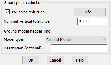
Smart point reduction
This option will deduct level points from the data and hence reduce the size of the generated ground model. The reduction is controlled by the "Nominal vertical tolerance" parameter which sets the approximate maximum relative level difference allowed compared with a pseudo surface at the point's general location. E.G if the parameter is 0.25 then the finished ground model's level accuracy should not be much worse than +- 25cm from the original level points
The accuracy and point reduction effectiveness can't be guaranteed and is always dependent on source data but in a typical sample the amount of ground model triangles has been reduced from 90 Million to 7.5 Million with nominal vertical tolerance of 0.25.
Ground model header info
These options add information to the ground model file's header, this will be visible when selecting and browsing ground models for subsequent functions.