|
<< Click to Display Table of Contents >> Input general Co-ordinate file |
  
|
|
<< Click to Display Table of Contents >> Input general Co-ordinate file |
  
|
Purpose
To read co-ordinate files in a variety of formats, display the first 50 lines of data and to provide manipulation functions to enable subsequent input to the drawing. Assuming the co-ordinate data is presented one point per line separated by spaces, tabs or commas.
Operation
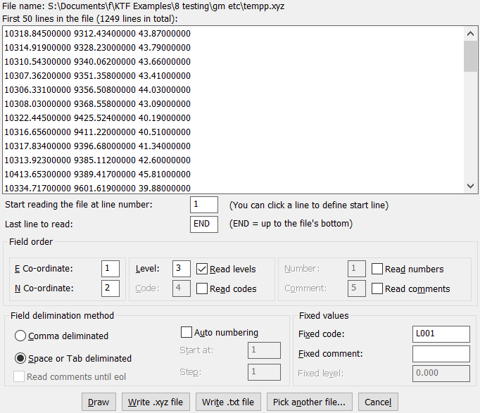
Select the input file and view the data. The E, N, L, Number and Code order can be changed together with other options within the dialogue to suit the format of the input file. If importing the data to CAD directly please see also Co-ordinate file Input for the point coding features.

Start reading at line number
Gives you an option to skip first n lines in case there is few header lines in the file for example. You can either click on the first co-ordinate line or type the line number in the edit field
Last line to read
END (default) will result reading the full file otherwise reading will stop at the specified line. Might be useful in case of a huge file and you want to have a look at a small sample of the data first before starting to read in it all.
E Co-ordinate, N Co-ordinate, Level, Read Levels etc.
Specify what to read from the file and at what location of the lines are the different data items. Easting and Northing has to be read in, other data is optional.
Field delimination method
Select either Comma or Space/Tab
Auto numbering
If numbers are not read in from the file automatic point numbering can be applied.
Read comments until eol
If comments are read in and are likely to have commas and/or spaces within them this option will result the comments to be read in fully. Note that in this case comments need to be located as the last data items in the data.
Fixed values
When Codes, Comments or Levels are not read in from data they can be assigned fixed values.
Draw
This button will take you to the main Co-ordinate file Input dialog, ready to import (draw) the data into a CAD drawing.
Write .xyz file
Will generate a file with space deliminated XYZ co-ordinates
Write .txt file
Will generate a KTF formatted Co-ordinate file. See Edit .txt Co-ordinate files
Pick another file
Select another file for input