|
<< Click to Display Table of Contents >> Levels onto 3D Polyline(s) |
  
|
|
<< Click to Display Table of Contents >> Levels onto 3D Polyline(s) |
|
Purpose
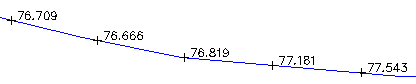
To add levels into the drawing with their locations and values defined by one or more 3D Polylines.
Operation
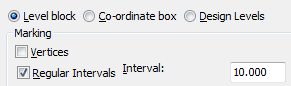
Select one or more 3D Polylines and set the layer and nominal scale. Typical choices for survey data would be "Level block" at "Regular intervals" of 10.000 metres. If the "Design Levels" option is used there are a number of different level blocks to choose from with different positioning and insertion points etc. To add levels at locations defined by 2D Polylines crossing 3D Polylines use option "Intersections with 2D Polylines". The "Align to Polyline" option will rotate the levels in relation to the 3D Polyline with 0deg. fixing the levels parallel.