|
<< Click to Display Table of Contents >> Output from Polylines |
  
|
|
<< Click to Display Table of Contents >> Output from Polylines |
|
Purpose
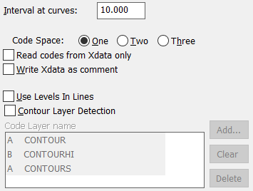
To write a feature coded co-ordinate file from selected 2D and 3D Polylines (not including curve fitted Polylines). Lines (2D and 3D), arcs and circles are also recognised. Codes are generated by layer. See the Translators sections to convert KTF .txt co-ordinate files into MX Genio format.
Operation
Enter the output file name and select Polylines. "Interval at curves" defines output interval for arcs etc. "Code Space" One = first character of layer name for first character of code, Two = first two characters of layer name for first two characters of code etc. "Read codes from Xdata only" will use extended entity data to fix the code that exists when input has been from survey datalogger or codes added by menu item Polyline utilities, Xdata Editor. "Write Xdata as comment" will use extended entity data as a comment (with code from layer name). "Use Levels in Lines" controls the use of levels from Lines. "Contour Layer Detection" relates 2D Polylines on specified layers as contours in the output file.