|
<< Click to Display Table of Contents >> Slope |
  
|
|
<< Click to Display Table of Contents >> Slope |
|
Purpose
To provide presentation options to show slopes or gradients from a survey/existing site or design model such as a junction or roundabout. A useful output for grounds maintenance applications is to calculate the slope areas for a specified range of gradients.
Operation
Select the model.

Settings to show downhill slope directions
Amount (gradients/steepness)
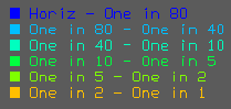
Setup... to assign colours to specified range of gradients (maximum of six) and to draw as Solid entities or 3D Faces plus Draw colour key.
Note that six different shades of grey can produce good results.

Steeper yellow, flatter blue
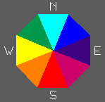
Direction (downhill/facing) colour mapping
Setup.. to show downhill arrows with the option of slope value annotations plus theoretical crests and streams.
For typical use ensure that Direction Colour mapping is disabled.

Settings to show downhill slope directions

Downhill arrows - note that the size of the arrows is related to the size of the triangle and not the steepness

Direction colour mapping can be drawn with 3D Faces or Solids and with its own colour key :-
Settings can be saved to and read from a .hil file