|
<< Click to Display Table of Contents >> Z value |
  
|
|
<< Click to Display Table of Contents >> Z value |
|
Purposes
1.To provide a graphical representation of the Z values in a model when typical output may be thought of as "colour filled contours".
2.With a difference model created by menu item Ground Modelling, Volumes the Z values represent amounts of cut and fill. You can present the cut and fill depths as a coloured map (isopachytes) and also report the cut and fill volumes based on depths.
3.When a visibility model has been output by menu item Ground Modelling, ZTV the Z values normally relate to how many targets are visible and results may now be presented with user defined colours. From KTF version 8.5812 onwards a ZTV Target filter option is also available with visibility models.
4.To draw a horizontal water surface or flood area defined by specific water level.

Colour mapping with CAD colours
Operation
Select the model and the dialogue appears. Note the range of Z values in the model – these may be actual existing or design levels, cut and fill amounts or relate to the number of ZTV targets.

Dialogue example for quick Automatic assignment of CAD colours
Choose the colour definition method :-
CAD colours to select from the CAD Colour Index (colour by numbers as above). Each band is drawn on its own layer.
or
True colours to use the far greater range and produce "smoother and more subtle" results.

Colour mapping with true colours
CAD colours
Add
To individually add a new colour band by entering start and end Z values and assigning layer and colour.
Auto
To assign bands automatically. Overwrite the defaults if required. Start and end Z values are rounded to the nearest metre with colour numbers starting at 10 and incrementing at intervals of 10.
Transform
To modify the elevation bands. The Divide Z range automatically option enables a "favourite" colour banding that was saved in a .ele file to be expanded or reduced over the vertical range. The Start Z and interval settings enable modifications to the start or lowest Z value and interval. To reverse automatic banding enter the highest Z value as the lowest Z value in the dialogue and interval of -1.000 for example.
Edit
To edit a highlighted colour band.
Delete
To remove highlighted colour band from the list.
Clear
To remove all bands in list.
Open
To read colour banding from an existing .ele file.
Save as
To write colour banding to a .ele file.
True colours
Add
To select start colour and set the span or range. Default is to divide the vertical range into 128 steps but this can be changed by the slider and "fine tuned" with the keyboard left and right arrow keys. For a cut and fill presentation good results may be achieved by setting three or four steps from the lowest fill value (rounded down to a suitable value) for the Bottom Z up to 0.000 and then click the Add... button to set contrasting colours with three or four steps from 0.000 to the Top Z (rounded up to a suitable value).
 and 3 steps for fill (green shades)")
Cut and fill example from difference model with 3 steps for cut (red shades) and 3 steps for fill (green shades)
Select... to fix the start colour and user the sliders to achieve your choice of colours.
Layer... to fix the layer for the colour mapping.
<-Previous and Next-> buttons enable to control what "set" you work on.
Edit
To edit elevation bands.
Clear
To remove all bands.
Open
To read the true colour banding from an existing .caf file.
Save as
To write colour banding to a .caf file.

Settings after bands have been defined and to calculate volumes.
Output settings
Draw Solids
Suitable for 2D plan presentation.
Draw 3D Faces
Suitable for 3D views.
Draw Polylgons (for hatching)
This option is only available for models created with Gridding. Draws closed 2D polylines for each Z value band.
Zoom extents
To easily see all the colour mapping when drawn.
Volumes
This option is available only for Differencial Models. Calculates the cut and fill volumes for each Z value band. After calculating use the Report file... button to write the report file as below :-
Cut depths Volume Area
0.000 to 0.500 41.0% 786 1855
0.500 to 1.000 27.0% 518 1206
1.000 to 1.500 18.2% 348 894
1.500 to 2.000 10.1% 194 539
2.000 to 2.500 3.3% 63 231
2.500 to 3.000 0.3% 6 41
Fill depths Volume Area
0.000 to 0.500 47.4% 930 2070
0.500 to 1.000 28.0% 548 1543
1.000 to 1.500 12.0% 235 693
1.500 to 2.000 8.0% 156 374
2.000 to 2.500 4.4% 86 252
2.500 to 3.000 0.3% 6 63
Decimals
Number of decimals in volume values. With very small amounts it is handy to have more accurate values than whole cubic metres.
Z Projection
True Z values
Outputs represent actual Z values in the model.
Upper limit(s) e.g. water
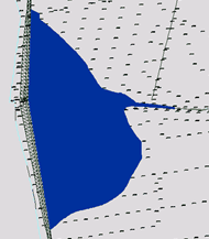
Typical use is when just one elevation band has been defined in CAD colours (e.g. as blue) to define a flood or water level and the output Solids or 3D Faces will show all areas at or below the upper Z value in the band (the lower level should be 0.000 or less if some levels in the site are close to sea level for example). If this setting is applied to the whole band set then the result if output as 3D Faces and rendered produces a terraced effect.

Rendered terracing
Flat surface (0.000)
To draw Solids or 3D Faces at 0.000 elevation (2D output).
Drape on 2nd model
To lay over or project the colour analysis results onto a 2nd model. This is useful for presenting cut and fill or ZVI result colour mapping onto what would typically be the original survey ground model. Output should be set to 3D Faces.
Calculate and Draw
Click to calculate the bands and draw as Solids or 3D Faces.
The areas for each colour band are displayed in the dialogue if using CAD colours.
Report file...
To write a report file following the above calculation.
Colour Key
To provide a key to the colour and Z value relationship. Note that where there are more than one "sets" of true colours the keys need to be drawn separately and in the cut and fill example below they have been repositioned.

Real colours key

CAD colours key
Filter by Targets
When a post KTF V8.5812 visibility model is selected an additional option to filter the colour banding by selected Targets. This enables to present the visibility of the western side of the project with different colour than eastern side's visibility for example.
Select the Target(s) you want to include in colour banding and proceed normally. Only the areas where Receptor can see the selected Target(s) will be coloured.

Target Filtering is specific for ZTV visibility models only