|
<< Click to Display Table of Contents >> Average within area |
  
|
|
<< Click to Display Table of Contents >> Average within area |
|
Purpose
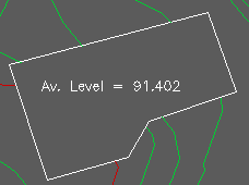
To report and annotate the average level within a closed 2D or 3D Polyline. This can help when designing slabs, footprints, sports pitches and car parks etc. and where a balance of cut and fill is required.
Operation
Select the model. Pick one closed Polyline. Return to accept the default sampling interval – reducing this will increase the accuracy of the calculation. Enter "Y" if the average is to appear as annotation, enter nominal scale, set layer and pick location. To move the Polyline from its initial elevation (it will typically be a 2D Polyline with an elevation of 0.000) enter "MV" at the command prompt, select the Polyline and the average level will appear as the default to move the Polyline vertically by (to represent close to a balance of cut and fill).