|
<< Click to Display Table of Contents >> Gradients along 2D Polyline |
  
|
|
<< Click to Display Table of Contents >> Gradients along 2D Polyline |
|
Purpose
To report the gradients (and level and chainage or offset) of any picked location on any section with options to mark and annotate.
Operation
Select the datum line and pick the 2D Polyline on the section representing existing ground or design.
Pick a location where you need to see what the gradient is (this is used to define the chainage).
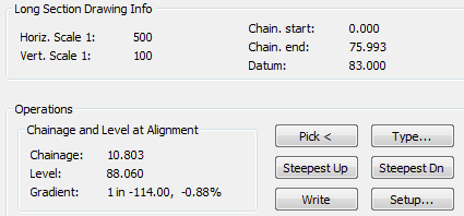
Long Section Drawing Information or Cross Section at chainage
Displays section information.
Operations
Pick <
To select a new location.
Steepest Up
To identify where the steepest uphill gradient occurs.
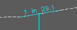
Write
To mark and annotate the current location on the section.
Type...
To hand enter the chainage or offset to report its gradient.
Steepest Down
To identify where the steepest downhill gradient occurs.
Setup
To assign chainage or offset and level annotation to correct boxes and lines, set number of decimal places and display as "one in" or %.