|
<< Click to Display Table of Contents >> Levels and 3D Polylines from plan |
  
|
|
<< Click to Display Table of Contents >> Levels and 3D Polylines from plan |
  
|
Purpose
The typical use is to provide a means of adding features such as bridges onto an existing river channel section.
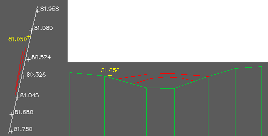
Start with an existing section or cross section, the plan location of the section represented as a 2D Polyline and the additional features to be added represented as 3D Polylines or level blocks.

Existing section (green), 2D Polyline (white) representing the section plan location, levels the section was created from (white and for illustration only), features to be added in red and yellow.
Operation
Pick the datum line of the existing section.
Pick the 2D Polyline representing the section plan location and Return.
Select a number of level blocks or 3D Polylines.