|
<< Click to Display Table of Contents >> Levels (inverts and soffits) from plan |
  
|
|
<< Click to Display Table of Contents >> Levels (inverts and soffits) from plan |
|
Purpose
To provide a means of showing levels along a 2D Polyline in plan (e.g. representing a horizontal alignment or river centre) on a long section. Typical use is for river or drainage related work. Use these codes to define the type :-
PILL |
Invert Level Left bank |
PILR |
Invert Level Right bank |
PILx |
General Invert Level ("x" is any character other than L or R) |
PSLx |
Soffit Level ("x" is any character) |
Any other codes will be a general level.
Operation
Click Invert levels from level blocks along a 2D Polyline for typical use.

Starting with level blocks representing invert, soffit or general levels
Pick the 2D Polyline representing the river centre for example.
Select the level blocks.
Pick the datum line of the section.
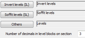
Assign layers for the levels on the section and the number of decimal places.

Levels added to section
Alternatively click Invert levels from a .dat file so the level data is read from a level data file (see menu items Sections, Sections from level data)