|
<< Click to Display Table of Contents >> Strata Model |
  
|
|
<< Click to Display Table of Contents >> Strata Model |
|
Purpose
To generate a strata surface model by combining the more dense ground surface survey with the underground level information from sparse data like from boreholes, trial pits and such.

Illustration about the strata model's benefits. If a model is being made directly from the borehole depths then a section through that model would appear to "hover" over the actual ground surface. However, the generated strata model will interpolate the strata depths more gradually following the surface elevation.
Operation
New strata model will be created by first cloning the ground surface model's triangles and then assigning AOD levels to the new model. The new strata level values will be calculated by interpolating the depths of the strata from ground surface at known locations. (The known locations being at boreholes and trial pits.)
Select the ground surface model. This be be the base of the strata model, the new model will have the triangles from this model but the levels will be adjusted to the assumed Strata levels.
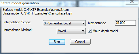
Interpolation Scope |
When assigning level values to the new, strata model. In scale of 1 to 6 how much weight will be put to nearest borehole level information where 1 results averaging the level values more and 6 calculating the levels mostly based on the nearest borehole's level.
|
Interpolation Method |
Use 1) The average of borehole levels based on their distance, 2) Calculated projections to gradients or 3) Both (="Mixed") . Note that both methods weigh the values based on the Scope parameter above.
|
Max distance |
The distance limit for a borehole to be accounted for for level adjustment.
|
Make depth model |
Make an optional depth ground model. If contoured this model will illustrate the depth of the new strata model from the ground surface. |