|
<< Click to Display Table of Contents >> Gradient to a location |
  
|
|
<< Click to Display Table of Contents >> Gradient to a location |
|
Purpose
To report and define a point as related to the Master String. One use would be to calculate the cover level of a manhole as fixed by the cross fall from the Master String.
Operation
Pick the Horizontal Alignment and select the .vtg file.
Pick a 2D location.
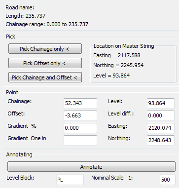
The chainage and offset etc. in relation to the Master String are calculated and displayed in the dialogue. By entering a gradient the level at the picked chainage is calculated and may be annotated in the drawing.
Pick Chainage only <
Returns chainage of picked point and keeps existing offset.
Pick Offset only <
Returns offset and keeps existing chainage.
Pick Chainage and Offset <
Returns chainage and offset - this is suitable for typical use.
Annotate
To mark the location with a Level on the specified layer.